Showing posts with label map. Show all posts

How To Subscribe to DeadCellZones.com Map Database Using Your Google Account

How to Subscribe

Subscribing to Deadcellzones.com is simple:

  1. Visit the Deadcellzones.com website.
  2. Use your Google account to sign in and start accessing the comprehensive cell phone dead zones database immediately.

Affordable Pricing

  • $0.03 Per Day
  • $1 Per Month for access to the Map Database
  • 7-Day Risk-Free Trial: Try it out with no obligation and cancel anytime.

💥 All-Access Map Bundle: 22 Maps for $9.95/month (FREE 7-DAY TRIAL)

Syndicated Maps bundled subscriptions

Syndicated Maps has recently launched a value-packed bundled subscription that gives users access to all 22 of its niche maps for just $9.95 per month—a savings of over 50% compared to subscribing individually. This all-access plan was created in response to user demand for a more affordable way to explore multiple data layers across traffic enforcement, environmental hazards, wireless coverage, energy infrastructure, and public safety. Whether you're a researcher, commuter, traveler, or concerned homeowner, this bundle lets you seamlessly tap into detailed, location-based intelligence from across the entire network.

Each map serves a specific purpose—from helping drivers avoid speed traps to alerting families about nearby environmental hazards. The Syndicated Maps network has earned the trust of millions of users annually, including commuters, journalists, health professionals, and urban planners. 

Why Choose DeadCellZones.com?

Are dead zones, dropped calls and slow data speeds frustrating you? DeadCellZones.com is your ultimate solution for staying connected wherever you go. We provide comprehensive coverage maps and insights into cellular service quality, ensuring you're always in the know about the best networks in your area.
  • Accurate Coverage Maps: Our detailed maps pinpoint areas with poor coverage, so you can plan your routes and avoid dead zones.
  • Carrier Reviews and Ratings: Get real-time reviews and ratings from users like you, helping you choose the best carrier for your needs.
  • Community Insights: Join a community of users sharing their experiences and tips on improving connectivity.

Why Subscribe

  • Exclusive Access: Subscribers enjoy exclusive access to map data, add new locations, and search the map.  
  • Updates: Receive alerts about network improvements, new cell tower installations, and special offers from carriers.

Join the DeadCellZones.com Community Today

Don't let poor connectivity hold you back. Join DeadCellZones.com today and experience a new level of connectivity awareness. Whether you're traveling, working, or at home, we're here to ensure you're always connected when it matters most.

Community Engagement

Join a community of drivers dedicated to identifying cell phone dead zone locations. Deadcellzones.com encourages user feedback and updates, ensuring the database remains robust and reflective of real-world conditions. We update our database daily, adding and removing locations as needed. 

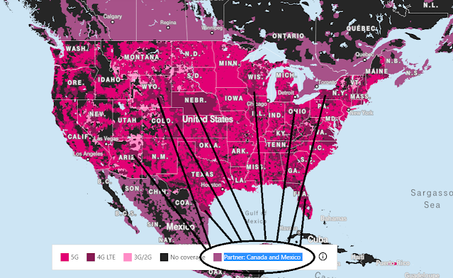
T-Mobile's Domestic Roaming Partner Map Is Not Always Accurate

T-Mobile Domestic Roaming Partner Map

Why is my phone on T-Mobile Domestic roaming when the coverage map says I'm in an LTE area?

Where Does AT&T Have 5G & 5G+ Coverage?

AT&T 5G Coverage Map

By committing to 5G requirements back in 2016, AT&T began running on a 5G network. Presently, with their low-band and millimeter wave spectrum network, they are already serving customers. The coverage map of AT&T 5G includes 190 regions of approximately 120 million individuals by April 2020. Of these, the low-band network encompasses 80 million individuals.

How To Check For Cell Phone Coverage By Address

When it comes to choosing the best mobile operator, most people think of the Big Three. The Big Four are known as AT&T, Verizon, T-Mobile / Sprint.  However, but they should also include a number of other smaller MVNO carriers that use these major networks.    

All four networks are available in the US, with AT&T, Verizon, T-Mobile, Sprint each having their own LTE networks. According to paid studies most carriers will claim they have coverage everywhere but we know this is not true.  Coverage only matters at your home address and the only way to check this is by asking someone else in your area, trying it out, or by looking at coverage complaints submitted by customers on the cell phone coverage reviews map above or on the check cell coverage by address mobile map.     

check for cell phone coverage by address

You can search this map to see which areas have the worst overage on each of the four major networks in the United States. Use the small search circle in the lower left-hand corner of the map. This map allows you to filter coverage reviews of all major mobile networks by simply clicking on the carrier on the right-hand side of the map.     

Enter your country, city, postal code, home or office address select your current location, filter by carrier type and region, and select the best and worst coverage in your area for each of the four major networks in the United States. In this example, you choose one of four different types of mobile towers for the USA and specify a country.     

Use can other tools like RootMetrics, OpenSignal, CellReception.com, or SignalMap to see what others are reporting about the range of the operator in your area based on positive signal strength.  However, these providers do not allow you to provide reviews on carriers in specific locations.  There is also a map to look at cellular towers and antenna locations nearby.      

RootMetrics does not have a map of the mobile towers in the viewfinder, but in some areas, it shows the cell signal quality. Although Root Metrics does not have a map of mobile towers, it is a strong indicator of signal quality in your area.     

Note that all carrier coverage maps show the general area of coverage, but not specific cellular towers or antenna locations near you. All carrier coverage maps somewhat inform users about the type of coverage and signal quality you can expect based on the address you enter in the search bar, as well as the display of cellphones and transmission towers.     

T-Mobile Tower Map lets you enter your zip code, locate a location on the map, and see if 4G LTE coverage is available. Search for T-Mobile 5G coverage from your current location, and it's available in all 50 states and Puerto Rico.     

Sprint gives you the ability to look up any address you want and allows you to see the coverage that's in your location. To access the website you are using, such as T-Mobile Tower Map, first, enter your address in the search engine of our website. Go to our mobile phone comparison engine and check the coverage at your exact location, and you will begin to gain a better understanding of coverage at the sites you are using.

Campground Cell Phone Coverage Reviews

Cell Phone Coverage Reviews vs Campgrounds Map

Cell Phone Towers Map vs Campgrounds Map

Today, we launched two new comparison maps that will help you find cell phone reception at campgrounds all over the United States.  

The 1st map on the upper left shows you 70,000+ cell phone coverage reviews submitted by our users.  Click on these pins to read the specific reviews and comments.  The map to the upper right is a map of 28,000+ campgrounds.  Click on these pins to get the specifics of each campground.   

The 2nd map below shows 100,000+ cell phone towers vs 28,000+ campgrounds.  Use this map and submit new coverage reviews directly by clicking on the +.  

These two maps are showing the Grand Canyon as example.  However, there are over 28,000 campground sites in the database.  

We are looking to build out more cell phone coverage reviews at campgrounds this summer.  

How to Add New Cell Phone Tower To Map

cell phone tower map
New Map to Compare Dead Cell Zone Complaints & Cell Phone Towers

Deadcellzones.com recently launched a new map to compare cell phone tower locations and coverage problems.  The map on the left is our traditional dead cell zones map.  The map on the right is a database of 170,000+ cell phone tower locations provided by the FCC.

If a cell phone tower is not on our map (right side) you can now add it by clicking on the + icon on the upper right corner of the map.  Please add new DAS antennas as well if they are not on the map also.

Here is an example of Telluride, Colorado where we discovered a new cell phone tower on top of the mountain that was not included in the data provided by the FCC.  We don't know who owns the tower so that information is left off of the map.  However, we assume the ski resort of Telluride likely owns the tower since it is located on top of the mountain.

What is most shocking is that T-Mobile provides better coverage at 13,000 feet on a hike than they do at 9,500 feet in the town of Telluride.  Go figure.  When we were on vacation in Telluride, CO during our vacation there was zero coverage in town.  There was adequate coverage in the Mountain Village.

These two tweets were sent to T-Mobile to alert them of this potential safety hazard.

Cell Phone Coverage Map Updates


Finding the best cell phone coverage just got easier by comparing cell phone coverage reports from other customers. We have updated our Cell Phone Dead Zones Coverage Map with the following new data features and information:
  • All blanks or entries with nothing in the description have been deleted.  78,289 records were in the database as of today and approximately 28,320 were deleted because they were left blank or didn't have any description of the reception problem.  There are 49,969 active records in the database from 2008-2016 as of today.  
  • Dates have been added to all entries and you can search by year or month. 
  • Record numbers have been added to all entries from 2008-2016.  If you see a number between 1-49,696 then it has been added to the database before December 16, 2016.  If carriers or customers think reception problems have been fixed that are currently on the map.  Simply send us a list of the records that you would like to deleted. A description of why we should delete would also be helpful. 
  • Search the map by data or description for a particular problem by city, state, zip or by a keyword in the description.  (Example: "school", "hospital", "airport").  
  • Every point on the map will have some context of the problem a customer is experiencing.  We will not longer be keeping blank data entries on the map. 
  • Email us if you would like a download of a particular region.

How to Compare Wireless Coverage

Wireless coverage maps stacked to compare coverage
We just launched a new tool to Compare Wireless Coverage from T-Mobile, AT&T, Verizon, Sprint & US Cellular.  We are hopeful that AT&T, Verizon & Sprint can provide us with a similar iframe map to make it easy for consumers to compare local coverage.  The great thing about the map provided by T-Mobile is that you don't have to leave the page to zoom into a particular location.Stay tuned to see if we can get a similar map from AT&T & Verizon.   

Google Maps Mobile Data Usage


Google Maps Mobile Data Usage

Google Maps is a huge data hog if you use it for navigation a lot.  Using Google Maps for navigation can easily send you over your 2GB data plan per month in a hurry.  Why is the data not cached?  Why don't they prompt you to use the driving option which allows you to download a cached version?    What is causing so much data usage?  Is it the traffic data?  If you have gone over your 2GB monthly data usage on some carriers like T-Mobile your data will just stop.  Good luck getting directions if you are driving around and suddenly your data just stops.  Do the carriers give you any notification that you have run out of data?  No they just stop giving you service.   More notification is obviously needed.  

How Do Public Utilities Deal With Mobile Dead Zones?

What Does A Public Works & Utility Service Vehicles Deal With Mobile Dead Zones? 

Gas, phone, water, road & electric utility companies are more dependent than ever on mobile communications with their home office.  From scheduling appointments to ordering equipment to emergency services.  Communication is critical to solving problems quickly.  

What does a public utility truck do when they don't have service?  Can they prepare ahead of time to know if a particular service area is not going to have good cell phone service?  

It has been suggested by a public utility in California that there is a need to help their service people prepare before going into the field.  All public utility vehicles take work into the field and are heavily reliant on mobile platforms to perform that work.  Everyone knows of the dead spots so why not prepare by sharing these locations with us on a map.  Currently, most utility workers rely on local knowledge and don't have a map system for this knowledge.  

We are willing to share this information back with you for your mapping GIS solutions.  Send us your notorious dead zones and we will post the data directly to the map.  Most the public utility agencies use ESRI and our data can fit right into these mapping systems.  


Popular Posts