Showing posts with label dead spots. Show all posts

Do Carriers Fix Dead Zones? How Verizon, AT&T & T-Mobile Prioritize Your Reports

Do Wireless Carriers Care About Reported Dead Zones? What They Prioritize—and What Actually Changes

If you’ve ever stared at a “No Service” icon and wondered whether your complaint goes anywhere, you’re not alone. U.S. carriers do track dead-zone reports, but they prioritize fixes that move the needle for safety, compliance, and large groups of users. Understanding how your report flows through a carrier—and what issues jump to the front of the line—can help set realistic expectations and make your feedback more actionable.

How carriers ingest and use dead-zone reports

Wireless operators blend crowdsourced signals (speed tests, dropped-call stats, app telemetry) with formal trouble tickets from customer care and enterprise accounts. They also watch regulatory data and drive tests from their own RF (radio-frequency) teams. Your report is most likely to generate action when it aligns with measurable network pain—high drop rates in their counters, repeated tickets in the same sector, or a gap along a priority corridor (freeway, school zone, hospital, emergency-response route).

What you can do to boost impact

  • Report with exact location (GPS, closest address or intersection), time of day, indoor vs. outdoor, and what fails (voice/SMS/data/VoLTE/Wi-Fi calling).

  • File more than once if the issue persists and encourage multiple affected users (family, coworkers, neighbors) to submit reports—the clustering matters.

  • Pair a formal ticket with crowdsourced evidence (e.g., consistent speed tests over time) so NOC teams can correlate your experience with their KPIs.

If you want a public place to document persistent gaps and compare with other users, you can log and browse dead zones by carrier and location on community maps like DeadCellZones.com (a long-running, user-powered database of coverage gaps and call failures).

What takes priority (in plain English)

  1. Public safety & legal obligations
    Outages affecting 911/VoLTE calling, hospitals, schools, or evacuation routes jump to the top. Carriers may deploy portable cells (COWs/COLTs), enable roaming, or fast-track new sites.

  2. Densely used areas & major venues
    Stadiums, arenas, universities, tourist districts, transit hubs, downtown cores, and high-traffic highways get capacity upgrades (small cells, new spectrum, Massive MIMO) before low-density neighborhoods.

  3. Enterprise & government accounts
    Contracts with SLAs (airports, utilities, logistics hubs, public-safety agencies) get escalation pathways that can accelerate fixes—and sometimes guide where a new site lands.

  4. Chronic repeat failures
    Sectors with provable patterns—dropped-call spikes, RSRP/RSRQ thresholds, congestion beyond engineering targets—get slotted into the RF optimization queue (tilt, azimuth, neighbor lists, carrier aggregation, handover tuning).

  5. Build-ready opportunities
    Even when a fix is justified, permitting, backhaul, power, and landlord access can delay or kill a project. “Shovel-ready” small-cell locations or rooftops with existing power/fiber often leapfrog harder sites.

Real-world actions carriers actually take

  • Near-term: feature toggles (VoLTE/Wi-Fi calling fixes), neighbor-list/hand-over changes, antenna tilt/azimuth tweaks, adding carriers on existing bands, refarming LTE spectrum to 5G, enabling additional bandwidth on mid-band.

  • Medium-term: activating small cells on light poles/rooftops, upgrading radios to Massive MIMO, adding new spectrum blocks (e.g., n41/n77), new backhaul capacity, sector splits.

  • Long-term: brand-new macro towers or major site relocations—only when RF modeling, demand, zoning, and economics line up.

Carrier-by-carrier: What gets attention, how to report, and realistic outcomes

Carrier Where to report & what they look at What gets prioritized Examples of typical fixes Reality check on timelines
Verizon My Verizon app “Report a Problem,” device logs (drop codes), enterprise account tickets, internal drive-test & RF counters. Public-safety reliability, highways & commuter corridors, stadiums/venues, airports, dense urban cores, repeat-ticket sectors. Add C-Band (n77) carriers on existing sites, deploy small cells in downtowns and stadium districts, retune handovers, split sectors where one panel is overloaded. RF tweaks can be days–weeks; adding carriers on existing hardware weeks–months; new small cells months; new macro site can be 9–18+ months due to permitting/backhaul.
AT&T AT&T “Mark the Spot” functionality evolved into app feedback + customer care tickets; FirstNet data (public-safety network) feeds priority views; enterprise care. FirstNet/911 reliability, hospitals, gov facilities, school zones, interstates, enterprise campuses with SLAs. Activate/expand FirstNet Band 14 where feasible, add mid-band (n77) capacity, deploy COLTs for events or construction outages, retune uplink for indoor penetration. FirstNet-related gaps often move fast; capacity adds on existing gear are moderate; fresh site builds vary widely by city rules.
T-Mobile T-Mobile app coverage feedback, care tickets, crowdsourced performance (they lean heavily on large-sample telemetry), enterprise care (retail/logistics). 2.5 GHz mid-band (n41) densification in cities/suburbs, 600 MHz coverage fixes in rural, transit corridors, large multi-dwelling units where indoor coverage lags. Turn up extra n41 carriers, add small cells to offload busy macros, tweak roaming and VoLTE profiles, leverage 600 MHz for indoor/rural reach. n41 adds on live sites can be quick; small-cell permitting varies; rural macro infill depends on fiber/power access—can take many months.
UScellular & regionals Customer-reported tickets, roaming partner escalations, local field teams with truck-rolls. Rural highways, farming/mining areas, town centers, schools, critical infrastructure (water/electric), and roaming pain points that affect partner traffic. Antenna swaps for better downtilt/beamwidth, rural small-cell or repeater placements, VoLTE modernization, new backhaul to relieve congestion. Rural upgrades can be fast if the utility pole/backhaul is ready; otherwise timelines look like the nationals.

Note: MVNOs (Google Fi, Visible, Boost Infinite, etc.) ride on these underlying networks—your report still needs to flow through the host carrier’s RF/NOC processes to get fixed.

“Why hasn’t my dead zone been fixed?”—the unglamorous blockers

  • Permits & politics: Small cells can trigger city aesthetic rules, hearings, or moratoria. Macro towers can meet neighborhood opposition.

  • Backhaul: No fiber = no capacity. Microwave backhaul helps, but isn’t always allowed.

  • Power: Even a perfect pole location can be unusable if utility upgrades lag.

  • Economics: A handful of users in a remote spot may not justify a new site unless it hits a safety corridor, school, or enterprise demand.

  • Physics: High-rise concrete, hills/valleys, and foliage can beat RF. Sometimes the right solution is in-building (small cell/DAS) owned by the venue rather than the carrier.

Practical playbook: turning your complaint into action

  1. Document precisely: Screenshots of failed calls/SMS, speed tests, and timestamps; note device model and whether 5G/LTE/Wi-Fi calling was on.

  2. Report via multiple channels: App feedback + a formal support ticket; if you’re an enterprise customer, use your account rep’s escalation path.

  3. Aggregate neighbors/tenants: A cluster of reports tied to the same sector (same intersection or building) gets prioritized.

  4. Show patterns: Weekday commute hours? Inside a specific building? At one stadium gate? Patterns point engineers to root cause (coverage vs. capacity vs. interference).

  5. Propose build-ready options: If a property owner is open to rooftop equipment and has power/fiber, mention it—this removes major blockers.

For community-level visibility (and to compare notes with others nearby), you can log repeat issues on DeadCellZones.com and link your carrier ticket number so others can upvote and add evidence. Over time, these clusters can mirror what carriers see internally and nudge attention.

What “fix” you should ask for (by symptom)

  • Bars fluctuate, calls drop when moving → handover/neighbor list tuning; ask support to escalate to RF optimization.

  • Great signal, terrible speeds → capacity issue; ask about additional carriers, mid-band activation, or a small cell.

  • No indoor coverage but great outside → request Wi-Fi Calling profile check, VoLTE provisioning, or ask landlord about an in-building small cell/DAS.

  • Whole area dark after storms → outage with backhaul/power; ask if they can stage a COW/COLT until repairs finish.

Bottom line

Yes—carriers do pay attention to dead-zone reports, but not all reports are equal. Issues tied to safety, many users, or measurable KPI pain get action first. The fastest wins typically come from tuning and adding capacity on existing sites; brand-new sites require patience and local cooperation. Make your reports count by being precise, persistent, and organized—and where possible, align your ask with the carrier’s own priorities (safety corridors, high-traffic venues, repeat failures).

6G vs 5G: Can the Next Network Finally End Dead Zones?

By DeadCellZones.com • August 2025

5G promised gigabit speeds, ultra-low latency, and a new era of connectivity. But for millions of users, especially in rural communities and large buildings, dead zones never went away. Now, with 6G cellular on the horizon, the question is whether this next-generation network can finally deliver.

Smarter Networks, Not Just Faster

While 5G focused on raw speed, 6G’s pitch is about AI-native networks—systems that automatically adapt to location, device, and environmental conditions. This could mean fewer coverage blind spots, as the network learns to route and boost signals where users need them most.

Satellites in the Standard

6G will integrate non-terrestrial networks (NTN)—direct satellite-to-phone links—from day one. This could bring connectivity to remote valleys, ships at sea, and disaster areas without extra hardware. It’s a major step beyond 5G’s limited satellite trials.

Better Indoor and Urban Coverage

Using sub-terahertz spectrum and reconfigurable intelligent surfaces (RIS), 6G aims to push signals into urban canyons and deep inside buildings. RIS technology can reflect and shape radio waves, potentially eliminating dead spots in skyscraper districts, stadiums, and malls.

Near-Instant Latency

5G targeted 1 ms latency but rarely achieved it for consumers. 6G promises 0.1 ms latency, unlocking real-time applications like holographic conferencing, autonomous vehicle coordination, and mission-critical robotics—even in previously marginal coverage areas.

Built-In Sensing

6G networks will include RF sensing, enabling them to detect motion, presence, and environmental changes without GPS or extra sensors. This could allow networks to detect coverage disruptions and fix them on the fly.

Security and Sustainability

With quantum-safe encryption and energy-aware protocols, 6G aims to be more secure and greener than 5G. Lower power use could make it economically viable to expand coverage to rural regions where operating costs are a barrier today.

5G vs 6G at a Glance

Feature 5G 6G
Goal Faster speeds AI-adaptive coverage
Coverage Terrestrial towers Terrestrial + satellite (NTN)
Indoor Gaps Persistent RIS + sub-THz fixes
Latency ~1 ms ~0.1 ms
Sensing Limited Built-in RF sensing

What It Means for Dead Zones

If 6G’s features live up to their potential, today’s dead zones could become rare. With satellite integration, adaptive AI routing, and advanced indoor coverage tools, carriers will have fewer excuses for gaps. But as with 5G, the real proof will come from crowdsourced coverage maps—not carrier marketing.

Follow 6G developments and help map real-world coverage by reporting your dead zones on DeadCellZones.com.

The Promises of 6G: How Ubiquitous Cellular Connectivity Could Become Reality

As the world begins to settle into the era of 5G, researchers and telecom companies are already envisioning the next great leap—6G, the sixth generation of wireless technology. Scheduled to roll out commercially in the early 2030s, 6G promises to go far beyond faster speeds. Its bold vision centers on ubiquitous cellular connectivity, ensuring that every person, device, and environment is continuously and seamlessly connected.

While 5G has improved bandwidth, reliability, and latency, it still faces gaps—particularly in rural areas, at sea, or in disaster zones. 6G aims to close these gaps with a mix of advanced technologies, global coverage strategies, and intelligent network design.

How to Choose the Best Satellite Phone

satellite phones

Satellite phones, also known as sat phones, are essential communication tools for people who travel or work in remote locations where traditional cellular networks cannot reach. Unlike regular cell phones, satellite phones connect directly to satellites orbiting Earth, offering coverage in areas with no cell towers. They are widely used by adventurers, sailors, pilots, military personnel, emergency responders, and anyone operating in off-grid environments. But with so many options available, choosing the right satellite phone can be overwhelming. This guide will help you understand the key features, network providers, costs, and considerations that matter most when selecting the best satellite phone for your needs.

Why Satellite Phones Are Different from Cell Phones

Unlike smartphones, which rely on ground-based towers, satellite phones work by transmitting signals directly to satellites. This makes them more reliable in remote deserts, oceans, mountains, and disaster zones where cellular service is unavailable. However, satellite phones typically have slower data speeds, larger handsets, and higher costs compared to regular mobile phones. Understanding these trade-offs helps you make a smarter choice.

Step 1: Identify Your Coverage Needs

The first factor in choosing the best satellite phone is coverage. Not all satellite networks cover the entire globe. Some specialize in certain regions, while others provide near-global service. Popular satellite networks include:

  • Iridium: Offers truly global coverage, including poles, oceans, and remote areas. Best for travelers needing connectivity anywhere.

  • Inmarsat: Strong coverage outside the polar regions, widely used for maritime and aviation.

  • Globalstar: Affordable but has more limited regional coverage.

  • Thuraya: Popular in Europe, Africa, Asia, and the Middle East but with less reach in the Americas.
    Decide where you will use the phone most often. For explorers in extreme or remote places, Iridium is usually the most reliable option.

Step 2: Consider Voice, Text, and Data Needs

Not all satellite phones offer the same level of service. Basic models are designed mainly for voice calls and SMS, while higher-end devices support limited internet browsing and email. If your priority is emergency communication, a basic handset may be sufficient. However, if you need to send files, receive weather updates, or access email, look for phones that support higher data transfer rates. Keep in mind that satellite data speeds are far slower than 4G or 5G cellular networks, so expectations should be realistic.

Step 3: Battery Life and Durability

When venturing into areas without easy access to power, battery life is critical. Choose a satellite phone with a long standby time and sufficient talk time to last through emergencies. Many models come with external battery packs or solar chargers as accessories. Durability is equally important. Rugged models are designed to withstand extreme temperatures, water exposure, dust, and shock. Look for IP ratings that indicate resistance to water and dust, ensuring your device won’t fail when conditions get tough.

Step 4: Evaluate Costs and Plans

Satellite phones are more expensive than traditional phones, both for the hardware and the service plans. Handset prices typically range from $500 to $1,500. Service plans vary depending on usage:

  • Prepaid Plans: Good for short-term or occasional use. You buy a set amount of minutes that expire after a period.

  • Postpaid Plans: Best for frequent users, with monthly fees and bundled minutes.

  • Rental Options: Ideal for one-time trips or expeditions.
    Additionally, calling rates are higher than regular mobile calls, often $0.90 to $1.50 per minute. Some networks also charge for incoming calls. Comparing costs across providers helps avoid surprises.

Step 5: Look for Emergency Features

Many satellite phones now include emergency features such as SOS buttons that connect directly to rescue services or monitoring centers. This is especially important for sailors, climbers, and outdoor enthusiasts who may face life-threatening situations. Some models integrate GPS tracking, allowing your location to be shared in real time with emergency responders. If safety is a top concern, prioritize phones with these added features.

Step 6: Check Compatibility with Accessories

The right accessories can make a big difference. Car kits, docking stations, and external antennas extend the usability of satellite phones, particularly in vehicles, boats, or aircraft. Some models can also connect to smartphones via Bluetooth, allowing you to use your iPhone or Android device for messaging while the satellite phone provides the actual network link. Before buying, check if the phone supports accessories that match your lifestyle or professional needs.

Step 7: Portability and Weight

While satellite phones are bulkier than regular smartphones, size and weight still matter if you’re carrying them in remote environments. Some newer models are slimmer and lighter, designed for adventurers who prioritize portability. Larger, more rugged devices may be better for marine or aviation use where durability outweighs convenience.

Step 8: Understand Legal Restrictions

Not all countries allow the use of satellite phones. In some regions, they are restricted or banned due to security concerns. Countries like India, China, and Russia have strict regulations regarding satellite communication devices. Before traveling, research local laws to avoid confiscation, fines, or legal trouble.

Step 9: Consider Network Reliability and Latency

Different satellite constellations have different reliability levels. Low Earth Orbit (LEO) networks like Iridium offer stronger signals and lower latency because satellites orbit closer to Earth. Geostationary networks like Inmarsat may have higher latency but deliver stable connections within their coverage footprint. If you need faster call setup times and lower delays, LEO networks may be the better choice.

Step 10: Customer Support and Availability

Finally, choose a provider that offers strong customer support and reliable service. In emergencies, the last thing you want is a complicated process to troubleshoot your device. Check if the provider offers 24/7 support, replacement programs, and clear documentation. User reviews can also give insight into real-world reliability.

Comparison of Popular Satellite Phones

Here’s a quick comparison of leading satellite phones on the market:

Phone Model Network Coverage Key Features Approx. Price
Iridium 9555 Iridium Global Rugged, reliable voice/SMS $1,200
Iridium Extreme 9575 Iridium Global SOS button, GPS tracking, IP65 rating $1,400
Inmarsat IsatPhone 2 Inmarsat Global (excl. poles) Long battery, emergency button $700
Globalstar GSP-1700 Globalstar Regional Compact, affordable plans $600
Thuraya XT-LITE Thuraya Europe, Asia, Africa Lightweight, affordable $500

Conclusion

Choosing the best satellite phone depends on your personal needs, travel destinations, and budget. For global travelers and those working in extreme conditions, Iridium models provide unmatched coverage. For maritime users, Inmarsat is a strong choice. Thuraya and Globalstar may be more cost-effective for regional use. Key considerations include coverage, durability, battery life, emergency features, and service costs. By carefully weighing these factors, you can select a satellite phone that ensures reliable communication in even the most remote corners of the world.

Related Stories:

Are Satellite Phones Expensive & How Much Are Plans?

What Tech Did Pasadena Police Use To Catch Murder Suspects?

Pasadena Police Lt. Gomez used technology and the investigation pointed to the suspects targeting victims in remote areas with poor cellphone reception while they were distracted during the assaults.

What State Has the Worst Cell Phone Coverage? A Comprehensive Analysis

In today's digital age, staying connected through our cell phones has become a necessity. Whether for work, social interactions, or emergencies, reliable cell phone coverage is crucial. However, not all states in the United States offer the same level of service. In this article and video, we will conduct a comprehensive analysis to identify the state with the worst cell phone coverage, exploring the factors contributing to its challenges and offering insights for users in that region.

How Recreation.gov Seeks Cell Phone Service Reviews at Campgrounds

Recreation.gov Seeks Cell Phone Service Reviews

Embarking on a camping adventure is a delightful way to reconnect with nature and escape the hustle and bustle of modern life. However, as technology continues to be an integral part of our lives, staying connected during camping trips has become essential for many outdoor enthusiasts. Recognizing this need, Recreation.gov, the go-to platform for discovering and reserving federal recreation areas, has taken a step towards ensuring campers can access cell phone service when needed. In this article, we'll explore how Recreation.gov solicits cell phone service reviews at campgrounds, promoting a more informed and connected camping experience.

Are Satellite Phones Expensive & How Much Are Plans?

satellite phone plans chart

Yes, satellite phones tend to be more expensive compared to traditional cellular phones. There are a few reasons for this:

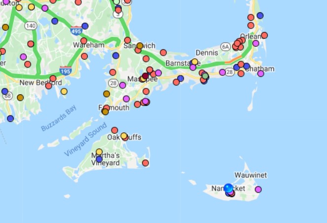
Nantucket is Full of Dead Zones & Residents Love It

Nantucket & Martha's Vineyard dead zones map

I have, unwittingly, become instantly identifiable by my red knit cap. I have been wearing the cap each winter for more than a decade, and on days when I wear something else, I am invisible. Invisibility is hard to come by on a small island. Even though we are well into spring, the wind is unrelenting. Red stands out on foggy mornings.

“I saw you on the way to work,” a woman at the coffee shop says, her eyes narrowing, “iced coffee on a day as windy as this?”

You can’t get away with anything out here, but I suppose I’ve always lived in fishbowls.

There are other people who have these sort of identifiers — the woman who rides her bike to the post office each day, chaining it to a lamppost. The man who leaves his truck with the dented bumper running outside the grocery store. The people who have this place memorized just so, they barely look up from their book or newspaper to navigate the cobblestones or splitting sidewalks.

You’re never more than twenty minutes away from everywhere else, and with cell phones, you’re always reachable. A lot of my friends are looking for ways to disconnect from the cloud these days, and find their way back to the real world. Their every digital move is monitored. They talk of social media cleanses, “dumb” phones that resemble the kind of plastic brick you might have kept in the glove compartment for roadside emergencies fifteen years ago, and erasing digital footprints.

There’s another way to escape all that. Nantucket is full of dead zones, places where the cell signal evaporates, and pockets of space where no one can reach you. Most people see this as an impediment. One website, yes, we can’t stay away from the internet entirely, says that Nantucket’s cell service is better than Cuttyhunk Island and Monomy in Chatham (thankfully, seals do not make telephone calls), but worse than every other city and town in the state. (I was in a Boston harbor tunnel a few weeks ago and the signal was clearer than anyplace on the island.)

I can’t fix them, so I might as well look forward to the dead zones on my walks around the island. I’ve started to pay more attention along these stretches of beach and bike path, slowing down to see if there is something here I should be noticing. Why this zone among all the others? Funny, how much of the world is moved by things unseen.

As we head into yet another overwhelming summer, I urge my fellow islanders to embrace the dead zones. Go to that beach where your social media pages won’t load. Take a walk on that path where news alerts can’t find you. Be invisible, just for a moment. It’ll all be waiting for you when you get back into service or put on your red cap.

SiriusXM Roof Rack Interference

XM satellite radios will experience dead zones or dropouts if the receiving is not properly installed far away from the roof rack.  This interference will become a major problem especially when you are near a T-Mobile cell phone tower

Don't mount the antenna close to a roof rack. Adjust the rack so it's further away from the antenna. If you have a surfboard or something on the roof this will also interfere with the signal.  

Troubleshooting Tips for Common Signal and Audio Reception Problems Here are ways to identify and correct some of the common signal and audio reception problems you may encounter:
  • PROBLEM: XM RADIO DISPLAYS "CHECK ANTENNA" or "CHECK ANTENNA CONNECTION" or "ANTENNA"
  • Possible cause #1: The antenna is not properly connected to the Radio or Vehicle Dock, or the connection has become loose.
  • Solution: Check the antenna connection to the XM Radio or Vehicle Dock and make sure it has a good, snug fit.
  • Possible cause #2: If the antenna is properly connected to the XM Radio or Vehicle Dock, there may be a break in the antenna cable, or a problem with the antenna.
  • Solution: Replace the Magnetic Mount Antenna.
  • PROBLEM: XM RADIO DISPLAYS "ACQUIRING SIGNAL" or "NO SIGNAL"
  • Possible cause: The Magnetic Mount Antenna is not receiving a satellite signal.
  • Solution 1: Make sure the vehicle is outdoors with a clear view of the sky.
  • Solution 2: Make sure the antenna is mounted on the outside of the vehicle in an optimal location. (Follow the mounting tips described earlier for your vehicle type.)
  • Solution 3: Move the vehicle away from any obstructed area. For example, if you are parked in an underground garage, you should receive a signal after leaving the garage.
  • PROBLEM: There is static or loss of clarity in the XM Radio's audio
  • Possible cause #1: If you have connected the audio of your XM Radio to your vehicle's FM radio using the FM transmitter, the FM channel you have selected is most likely being used by an FM radio station. This interferes with the audio of the XM Radio.

Why Your Home Cell Phone Signal Has Stopped Working

cell towers vs distributed antenna systems
Cell Towers vs Distributed Antenna Systems

If you live in a rural area of the United States it is likely that your cell phone signal strength has been fluctuating or might have dropped entirely in recent years as carriers move from 3G to 4G LTE.  Wireless carriers are increasingly moving services in areas from the very tall cell phone towers to the smaller distributed antenna systems as you see in the picture above.  Why?  

These very tall cell phone towers can provide 2G, 3G, and 4G LTE coverage of 1 to 2 miles and service several thousand people and homes from a single tower.  Carriers are increasingly dealing with capacity issues on these tall towers and have to turn wireless signals down or off in areas on antennas where there are congestion problems (too many users) or not enough customers (not profitable).  

This could result in your home that previously had several bars of cell phone signal suddenly not having any signal at all.  The wireless carrier may put up a DAS system in your neighborhood to fix the problem if you complain enough.  DAS or Distributed Antenna Systems are essentially smaller and lower power cell towers that are installed on top or inside of buildings or utility poles most commonly.  DAS antenna systems will provide service to a smaller number of people.  The theory is that your signal will be more reliable and faster.  

Unfortunately, the FCC or FTC has no mandate for the wireless carrier they have to inform you of changes in signal strength in your neighborhood.  Carriers might not even reflect this coverage accurately on their coverage maps for several years.  Deadcellzones.com has been operating for the last 18 years collecting complaints on a map of where customers have trouble getting cell phone signals.  

The complaint latest trend in the industry seems to be carriers optimizing their networks in markets and dropping coverage for "unprofitable" markets.  There is no guarantee that coverage will be provided at your home and this is the biggest portion of customer traffic adding data to the dead zones map.  

I am curious what some homeowners have done to remedy this problem with carriers.  Please comment below if you have any feedback or suggestions on how to solve this problem with each carrier.  These carriers have gotten so big that bureaucracy is probably the biggest obstacle to getting solutions for customers who have lost good home cell phone signals.  

Campground Cell Phone Coverage Reviews

Cell Phone Coverage Reviews vs Campgrounds Map

Cell Phone Towers Map vs Campgrounds Map

Today, we launched two new comparison maps that will help you find cell phone reception at campgrounds all over the United States.  

The 1st map on the upper left shows you 70,000+ cell phone coverage reviews submitted by our users.  Click on these pins to read the specific reviews and comments.  The map to the upper right is a map of 28,000+ campgrounds.  Click on these pins to get the specifics of each campground.   

The 2nd map below shows 100,000+ cell phone towers vs 28,000+ campgrounds.  Use this map and submit new coverage reviews directly by clicking on the +.  

These two maps are showing the Grand Canyon as example.  However, there are over 28,000 campground sites in the database.  

We are looking to build out more cell phone coverage reviews at campgrounds this summer.  

New Weather Channel App Notifies You When Cell Networks Are Down

New Weather App Can Spread Urgent Alerts Even When Cell Networks Are Down
New Weather App Can Spread Urgent Alerts Even When Cell Networks Are Down. 

The Weather Company’s new Android app uses mesh networking to spread data between phones over Wi-Fi and Bluetooth. IBM, The Weather Company launch mesh-powered app for internet-poor regions.

Having a wealth of up-to-the-minute climate data at our fingertips is something most of us take for granted. Thanks to a reliable cell connection, our smartphones, and the work of hundreds of meteorologists and climatologists around the globe, keeping abreast of an incoming storm isn’t so much a matter of how, but how quickly. Unfortunately, though, that isn’t the case for everyone.

In developing countries, cellular connectivity is congested, intermittent, and in the worst cases inaccessible. That’s why IBM, in collaboration with developers at The Weather Company, introduced Mesh Network Alerts, a new technology that provides a peer-to-peer means of facilitating communications between residents of underserved nations.

Mesh Network Alerts work by linking mobile devices directly to one another, daisy-chaining handsets in a sort of node network. Using a combination of Bluetooth and Wi-Fi, each connected smartphone stores and propagates messages to devices within a 300- to 500-foot radius, creating a mesh that can effectively reach more devices. Read more

Long Range Wireless Intercom for Remote Job Sites

Long Range Wireless Intercom for Remote Job Sites
Discovered this product at CES 2017.  At last, I can talk to my colleagues in my field operations: saving time and improving safety when no cell phone coverage is available!  Startup Appi Technology from France that showcased at CES 2017.


Watch the interview with Appi about half way through.  

Cell Phone Coverage Map Updates


Finding the best cell phone coverage just got easier by comparing cell phone coverage reports from other customers. We have updated our Cell Phone Dead Zones Coverage Map with the following new data features and information:
  • All blanks or entries with nothing in the description have been deleted.  78,289 records were in the database as of today and approximately 28,320 were deleted because they were left blank or didn't have any description of the reception problem.  There are 49,969 active records in the database from 2008-2016 as of today.  
  • Dates have been added to all entries and you can search by year or month. 
  • Record numbers have been added to all entries from 2008-2016.  If you see a number between 1-49,696 then it has been added to the database before December 16, 2016.  If carriers or customers think reception problems have been fixed that are currently on the map.  Simply send us a list of the records that you would like to deleted. A description of why we should delete would also be helpful. 
  • Search the map by data or description for a particular problem by city, state, zip or by a keyword in the description.  (Example: "school", "hospital", "airport").  
  • Every point on the map will have some context of the problem a customer is experiencing.  We will not longer be keeping blank data entries on the map. 
  • Email us if you would like a download of a particular region.

CA Highway 74 T-Mobile Cell Phone Coverage

Despite what the map says there is no T-Mobile cell phone coverage in this area of Highway 74.


Can Drones Help Cell Phone Dead Zones?

drone plane for cell phones

Verizon Communications is testing the deployment of large-scale drones to provide mobile connectivity in emergency situations when the land-based cellular network has been damaged. But the carrier hopes the trials will also entice corporate customers who may want to use the connected drones for new business applications. Read more.

AT&T suggested in a blog post that it may consider using drones to provide better cell coverage at major public events like music festivals and sporting events. It is notoriously difficult for cellular carriers to provide adequate coverage to such large gatherings: cell towers often get overloaded with voice and data traffic during these events. So carriers normally bring in trucks loaded with equipment that helps extend cellular coverage to large gatherings.  Read more

How to Search Dead Zones Database Map

Word Cloud of Dead Cell Zones Database 
You can search for these locations on the dead zones map
See the map below for directions. 


Is RootMetrics Data Too Expensive?

RootMetrics vs DeadCellZones Map

RootMetrics just sold to IHS last year for what was reportedly a huge number.  Why?  Carriers and wireless regional tower operators/service providers buy their data for competitive analysis and determine which carriers could use coverage enhancements in certain markets.  How many service providers can afford the huge price for the data?  If you are in the industry you know what I mean.

RootMetrics claims to drive test (test signal strength) in under 100 markets twice per year.  Drive testing makes sense but it is anecdotal data and only a snapshot at that time.  Can RootMetrics possibly drive test during every rush hour in every location?  No!  Do RootMetrics have actual customer complaints? No!  Are they drive testing in rural and undeserved marketing?  No!  Do their maps tell you where problems exist?  Kind of.

Which map tells you more about where problems exist?  What RootMetrics doesn't have are actual customer coverage complaints like what we publish on Deadcellzones.com.  We get 3,000-5,000 people per day that visit our web site and contribute dead zones directly to the map.

If you are looking to purchase data from RootMetrics than you most certainly should also look at purchasing our crowdsourced Dead Zone data.  Positive signal strength data and negative signal strength information can be quite complimentary.  Contact us for further details on pricing and why we can help you save money.  

How Do Public Utilities Deal With Mobile Dead Zones?

What Does A Public Works & Utility Service Vehicles Deal With Mobile Dead Zones? 

Gas, phone, water, road & electric utility companies are more dependent than ever on mobile communications with their home office.  From scheduling appointments to ordering equipment to emergency services.  Communication is critical to solving problems quickly.  

What does a public utility truck do when they don't have service?  Can they prepare ahead of time to know if a particular service area is not going to have good cell phone service?  

It has been suggested by a public utility in California that there is a need to help their service people prepare before going into the field.  All public utility vehicles take work into the field and are heavily reliant on mobile platforms to perform that work.  Everyone knows of the dead spots so why not prepare by sharing these locations with us on a map.  Currently, most utility workers rely on local knowledge and don't have a map system for this knowledge.  

We are willing to share this information back with you for your mapping GIS solutions.  Send us your notorious dead zones and we will post the data directly to the map.  Most the public utility agencies use ESRI and our data can fit right into these mapping systems.  


Popular Posts